The hike at a glance
- When: Thursday, October 1, during the 6:00–7:30 PM Outdoors Adventure meeting.
- Where: Alexander Park, 800 Old Snellville Hwy, Lawrenceville. Meet at Home Base, Pavilion #1.
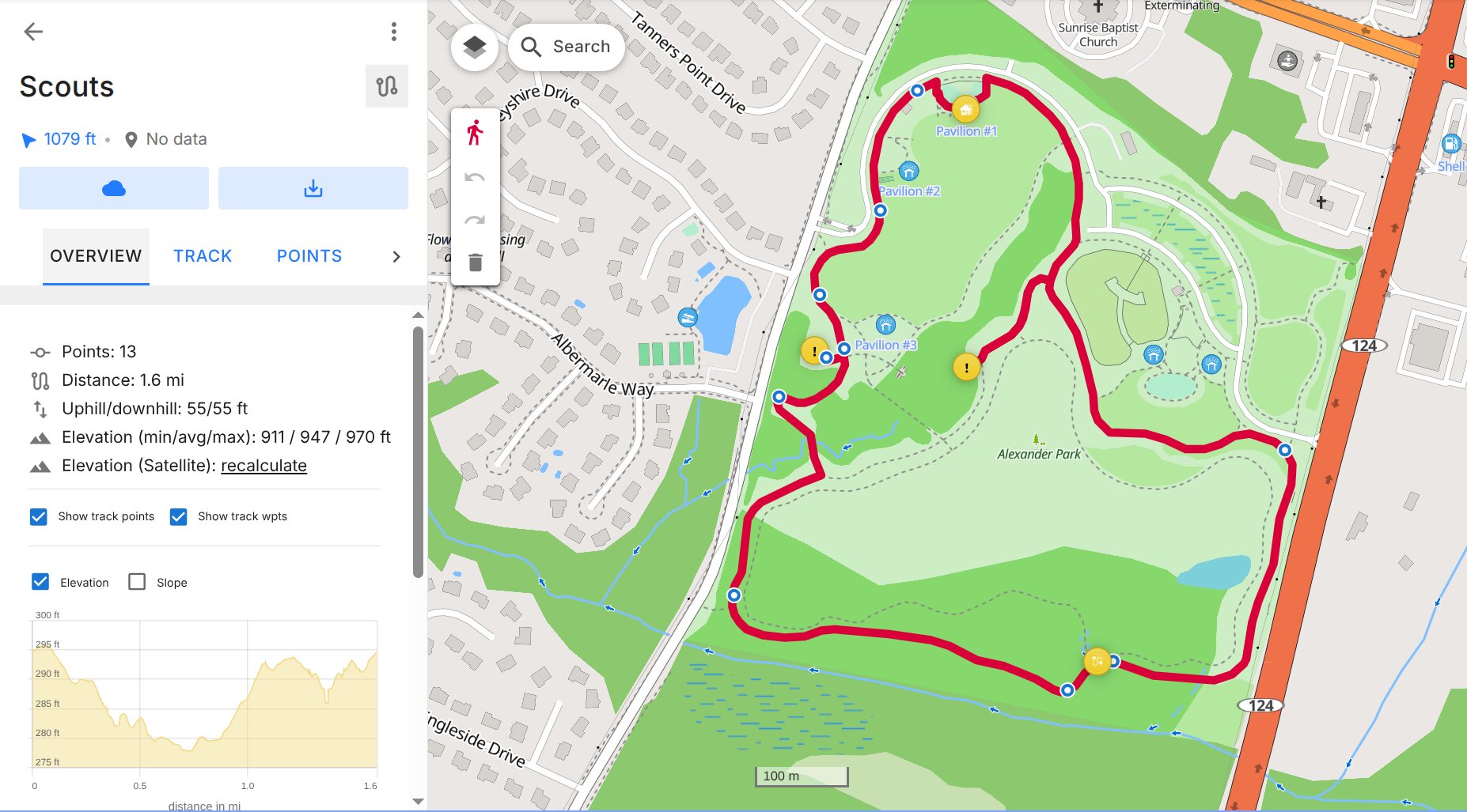
- Route: a loop of about 1.6–1.75 miles — Home Base → 1 → 2 → 3 → back to Home Base. Webelos Walkabout calls for a 2-mile walk, so leaders may add a short out-and-back near Pavilion #1.
- Who: Webelos and Arrow of Light Scouts, each with their adult partner.
- What happens: stops 1 and 3 have challenge cards — trail first aid for Webelos (Walkabout), packing and campout safety for Arrow of Light (Outdoor Adventurer). Stop 2 is just a checkpoint on the route.
What to bring
- Optional: your own phone with Organic Maps and the waypoints loaded, to follow along or help a Scout navigate
- Webelos: the Six Essentials
- A flashlight or headlamp; sunset is around 7:20 PM
- Water, closed-toe shoes, and clothes for the weather
The app: Organic Maps
Organic Maps is a free map app for iPhone and Android with no ads, no account, and no tracking. Its maps work offline, so it keeps navigating even where cell signal is weak, and it shows trails and footpaths that driving apps leave out. It doesn't need cell service: a phone or tablet with no SIM still gets GPS.
iPhone (App Store)Android (Google Play)
Backup: if Organic Maps won't install on your device, use OsmAnd instead (iPhone · Android). It opens the same GPX file.
Set it up at home (optional)
Leaders bring 3 devices that are already set up, so this is only for families who want their own phone on the trail.
- Install Organic Maps and open it. Allow location access (While Using the App is fine).
- Download the offline map. Search for Alexander Park Lawrenceville or zoom in on it; when the app offers to download the map for the area (Georgia), tap Download. Do this on Wi-Fi.
- Download the waypoints on the same phone: 2026-OutdoorAdventure.gpx.
- Open the file in Organic Maps.
- iPhone: open the Files app → Downloads, press and hold 2026-OutdoorAdventure.gpx, tap Share, and choose Organic Maps.
- Android: tap the finished download (or find it in your Files / Downloads app) and choose Organic Maps when asked which app to open it with.
- Check it worked. Tap the ★ Bookmarks button. You should see a new list (named Thu Oct 01 2026) with four yellow points: 1 - Event, 2 - Waypoint, 3 - Event and 0,4 - Home Base.
- Test it offline. Charge to 100%, turn on Airplane Mode, step outside, and wait for a GPS fix. Walk 50–100 yards and confirm the location dot moves. If battery saver interferes with GPS, turn it off for the hike.
Didn't get to it?
No problem — come anyway. Scouts can navigate with the leaders' devices, and a leader can help you set up your phone at the park.
On the trail
- Start at Home Base (Pavilion #1).
- In Organic Maps, open ★ Bookmarks, pick the next point, and tap Route To. Switch to the walking 🚶 mode.
- Let the Scout hold the phone and lead. Watch the distance count down and look around when you get close — GPS is only accurate to about 15–30 feet.
- Complete each stop, then route to the next one. Finish back at Home Base.
Scouts take turns at three jobs, switching at each stop: Navigator (holds the GPS), Map Checker (confirms the trail choice), and Outdoor Ethics Observer (spots Leave No Trace and Outdoor Code examples).
Tip: the blue dot's cone shows which way the phone is facing. If it seems wrong, wave the phone in a figure-8 to recalibrate the compass.
Waypoints
| Stop | Name | Coordinates | What's there |
|---|---|---|---|
| Start | Home Base | 33.91698, -84.00546 | Pavilion #1 |
| 1 | Event | 33.91466, -84.00721 | Challenge cards |
| 2 | Waypoint | 33.91166, -84.00393 | Route control only, no card |
| 3 | Event | 33.91450, -84.00545 | Challenge cards |
| Finish | Home Base | 33.91698, -84.00546 | Pavilion #1 |
Hike safely
- Every Scout stays with their adult partner, and every group stays together.
- Stay on trails and paths. Watch for roots, roadways, and other park visitors.
- Leave No Trace: leave what you find and pack out any trash.
- Head back to Home Base by 7:30 PM, or whenever a leader calls it.
⬇ Download waypoints (GPX)📄 Event packet (PDF)Back to Calendar